Manhood Peninsula Partnership Caring for Chichester’s Coastal Communities. The Manhood Peninsula Partnership was inspired by local residents to promote a sustainable way forward for addressing the environmental, social and economic challenges posed to the area by climate change.
Manhood Peninsula Partnership Coastal Management A large part of the Manhood is less than 5m above sea level and at risk from flooding, both inland and coastal. It is likely that climate change will increase this risk, through rising sea levels, rising water tables and increased precipitation intensity. Drainage is an increasing problem in the Manhood as the existing ditches are proving inadequate to handle increased run-off resulting from recent development and heavier rainfall. Plans...
Manhood Peninsula Partnership Climate Change The Manhood Peninsula is particularly vulnerable to the effects of climate change including rising sea levels, rising water table, and more intense precipitation. As a result, the MPP has been working closely with the community to raise levels of awareness and to help produce adaptation plans. These include: practical adaptations funded through a Community Grant Fund including the installation of cycle racks at East Wittering School; the provision of water butts...
Manhood Peninsula Partnership History The Manhood Peninsula Partnership was formed in 2001 following concerns raised among local residents about the need for greater co-ordination between the bodies and organisations responsible for the management of the Peninsula and their ability to work with local people to address present and future environmental, social and economic challenges. The MPP was formed in July 2001 as a direct result of a 5 -day workshop organised by local residents...

Manhood Peninsula Partnership

Coastal Management

Coastal Management

A large part of the Manhood is less than 5m above sea level and at risk from flooding, both inland and coastal. It is likely that climate change will increase this risk, through rising sea levels, rising water tables and increased precipitation intensity. Drainage is an increasing problem in the Manhood as the existing ditches are proving inadequate to handle increased run-off resulting from recent development and heavier rainfall.

Plans for the managed realignment scheme on the coast between Selsey and Bracklesham in the area known as Medmerry are now underway, and planning permission for the defense works will be sought towards the end of summer 2010 . The intention is to allow sea water to breach the existing shingle bank to create new salt-water and fresh-water habitat behind the Medmerry frontage.

The major reason for considering a managed realignment scheme is that the existing shingle bank at Medmerry does not provide the best protection to the low lying land and properties inland. Despite much effort to maintain the defences, the sea regularly causes breaches during storms letting water through that leads to flooding. As sea levels rise, repairing the defence will become increasingly difficult and may become impossible. An alternative way is needed to provide long term protection for the area.

The options to improve flood risk management as outlined in the Pagham to East Head Coastal Defence Strategy were assessed, and managed realignment was found to improve protection to most properties in the area. This included the area between Selsey and Bracklesham including Selsey’s only road link, the B2145 and the area’s sewage works.

The Environment Agency have now acquired the majority of the land that may be flooded by the tide following the realignment at Medmerry. Where the landowner demonstrated that selling part of the farm made a farm unviable, the rest of the farm was bought also. Managed realignment was found to be the best option economically and it can provide large environmental advantages too by creating additional habitat for coastal and intertidal species.

It is not yet clear exactly what habitat will form where, but experience from other realignment sites from around the country has shown that a variety of habitats form with a mixture of saltmarsh, mudflats and coastal grazing marsh. This mixture of habitats is expected to be something similar to that seen at Pagham Harbour. These habitats should start to form in the first couple of years after the defences are breached, but could take many more years to become fully established.

Brent Geese FlyingIn general terms, for intertidal areas it can be expected that ultimately over-wintering wildfowl (various ducks and geese) and waders will use the site in the winter, with populations of breeding waders during the summers. There will also be populations of worms, molluscs etc, as well as plants on the saltmarsh, and invertebrates. Intertidal habitat is also good for some fish species, providing areas for them to breed and feed.

The picture illustrating this page shows the shingle bank along the Medmerry frontage currently defending the inland areas from the sea. Maintenance of the bank is undertaken annually by the Environment Agency. An overview of local geology, including aerial photographs of the site can be found here.

For further information explore the Environment Links section of our website, particularly the following sections:

Coastal Management and Climate Change Links

Consultations, Reports and Policy Statements

Marine Legislation Links

Flood Risk Links

1950’s Selsey sea defences 
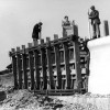
Sea defences have been required in the Manhood Peninsula for many years. A great deal of work was needed following a particularly bad storm in December 1951 which wrecked houses along the Selsey sea front, and led to their subsequent demolition.  Following is a gallery of images courtesy of...Continue Reading »